

A Risk Analysis and Decision Support System for Nuclear Accidents in the Mediterranean Area
Possible accidents in nuclear power stations around the Alpine area could have serious mpacts on all areas of the Mediterranean basin, as well as on the Mediterranean sea itself.The DIFURAD system – developed by a joint effort of various ENEA technical units – starting from the quantities of radionuclides released into the atmosphere following the accident, is able to predict their dispersion in the atmosphere, deposition on the ground and on the sea, possible dispersion in water and to simultaneously evaluate the effects of deposition, through the use of several information layers, both static (socio-economic) and dynamic (impact on transport and roads)
Un sistema di analisi del rischio e supporto alle decisioni per incidenti nucleari nell’area del Mediterraneo
Possibili incidenti nelle centrali nucleari della zona transalpina potrebbero avere gravi impatti su tutti i territori del bacino del Mediterraneo, oltre che sul bacino stesso. Il sistema DIFURAD, sviluppato all’interno di un progetto congiunto di svariate Unità Tecniche di ENEA, è in grado, a partire dalle quantità di radionuclidi rilasciati in fase gassosa dalla centrale a valle dell’incidente, di predirne la diffusione in atmosfera, la loro precipitazione sul terreno e sul mare, l’eventuale diffusione in acqua e contestualmente valutare gli effetti della deposizione al suolo, attraverso l’utilizzo di layer informativi di varia natura, sia statici (socio-economici) sia dinamici (impatto sui trasporti e la viabilit
DOI: 10.12910/EAI2013-07
R. Delfanti, M. Pollino, V. Rosato, L. La Porta, M. D’Isidoro, S. Sandri, M. Guarracino, E. Napolitano, M. Barsanti, V. Artale, P. Agostini, I. Delbono, F. De Rosa, A. di Sarra, E. Fantuzzi, R. Lorenzelli, E. Negrenti, P.M. Ruti, F. Padoani, G. Zanini
Introduction
The production of Energy in the European countries is largely based, for a considerable extent, on Nuclear Power Plants (NPP).
TABLE 1
|
Country |
Reactors in operation (under construction) |
Nuclear electricity as % of total generated electricity |
|---|---|---|
|
Belgium |
7 |
51 |
|
Bulgaria |
2 |
31.6 |
|
Czech Republic |
6 |
35.3 |
|
Finland |
4 (1) |
32.6 |
|
France |
58 (1) |
74.8 |
|
Germany |
9 |
16.1 |
|
Hungary |
4 |
45.9 |
|
Netherlands |
1 |
4.4 |
|
Romania |
2 |
19.4 |
|
Slovakia |
4 (2) |
53.8 |
|
Slovenia |
1 |
35.9 |
|
Spain |
7 |
20.5 |
|
Sweden |
10 |
38.1 |
|
United Kingdom |
16 |
18.1 |
|
Total |
131 (4) |
Nuclear power reactors in the EU in 2012 (source: 2012 Annual report of the EURATOM Supply Agency)
The geographical distribution of EU nuclear sites shows a remarkable concentration in the regions north of the Alps, on the French (7), Swiss-German (6) and Slovenian (1) sides.
This situation makes the Mediterranean area particularly vulnerable in the event of nuclear accidents, which, according to severity and nature, may release radionuclides into the atmosphere. Depending on the meteorological conditions, the released material may be transported all over Europe and also to various areas of the Mediterranean basin.
It is therefore crucial to provide the Country (and at the same time the Countries of the Mediterranean basin) with a forecasting system able, within a few hours, to produce qualitative and quantitative estimates of the potential risk to humans and the environment, and to support the prompt definition of emergency plans. The system should be based on realistic scenarios, defined by reliable models of radionuclide dispersion in the atmosphere and in the Mediterranean Sea.
The Fukushima accident recently highlighted the need for such a decision support system in case of accidents or sabotage to nuclear facilities or, in general, of events with significant dispersion of radioactivity. Fortunately NPP accidents represent rare disastrous events, albeit with dramatic consequences; prediction of their impacts is thus crucial to the scientific community, public decision makers, stakeholders, and citizens. ENEA, with its internal effort, has conceived and realized the DIFURAD system providing a number of scenario predictions which might be useful to all the cited communities.
Modern approaches to emergency management and response involve efforts to reduce the vulnerability to hazards, to diminish the impact of disasters and to prepare for, respond to, and recover from those that may occur.
The prototype of the DIFURAD system focuses on the design and development of an innovative methodology, based on geospatial methods, for mapping radionuclide releases from power plants after a severe accident, assessing the impact on the Italian territory and the whole Mediterranean basin and evaluating the consequences for population and the environment. The system integrates model predictions and geospatial data for mapping radionuclide diffusion, scenario definition and disaster planning. DIFURAD intends to respond to these needs and has, as enabling technology, high-performance computing platforms able to provide, within 6-12 hours after the event, reliable and accurate predictions of the consequences during the 7 days following the disaster. The prediction can be routinely updated based on the actual meteo-marine conditions. In particular, a preliminary methodology for mapping the radioactive fallout and its impact over a widespread area has been designed and related spatial resolution issues have been addressed and solved.
The European Framework
At the European level, user-friendly decision support systems for emergency and post-accident management have been developed in recent years. The RODOS system, Decision Support for Nuclear Emergency Management (Ehrhardt and Weis, 2000) was developed starting in 1989 through a series of EU projects. RODOS is designed to support decision making in case of a nuclear accident in the European area. It includes models to predict the atmospheric dispersion, an hydrological model chain (rivers, lakes, coastal areas) and the transfer of radioactive material through feed and foodstuff, but it is not specific for the Mediterranean area. The ERICA tool (Environmental Risks from Ionising Contaminants: Assessment and Management), also developed through EU projects (Beresford et al., 2007), helps decision makers to assess the impact of radionuclide inputs onto the environment (terrestrial, freshwater and marine) and to define countermeasures or mitigation actions. The system MOIRA-PLUS (Monte et al., 2009) is a decision support system based on validated models to predict the behavior of 137Cs and 90Sr in freshwater systems, to estimate doses to population and to evaluate various countermeasures and mitigation options. Recently (Monte, 2011) MOIRA PLUS has also been implemented for simulating the dispersion of radionuclides in the marine environment.
ENEA’s know-how covers all fields relevant to the development of the decision support system, from the characterization of the source term, to the radionuclide diffusion, transport in the atmosphere and the ocean, deposition, and radiation protection, to advanced systems for risk management for critical infrastructures. Leveraging on systems already developed under EU-funded projects, DIFURAD project’s team has developed an innovative system integrating observations and models for risk management specifically targeted at the Mediterranean area. It includes up-to-date atmospheric and hydrological models for the area, and integrates observations and model results in a WebGIS system, containing layers with land-use and socio-economic data, to give in a short time a reliable picture of the impacted areas, involved population, economic activities at risk. The system is conceived as a tool to support the authorities in charge for emergency and post-accident management and will be open to integration with tools and systems such as ERICA or MOIRA. The major beneficiary of the DIFURAD system, as for Italy, is the Italian Civil Protection Department, responsible for the operational coordination; the Department has been committed to this task by the “National plan of protective measures for radiological emergencies” [1] - approved with the 19 March 2010 decree of the President of the Council of Ministers – which identifies and regulates the necessary measures to manage the emergency tasks in case of incidents and pollutant emissions that occur in nuclear power plants outside the national territory.
The DIFURAD Project
The long term objective of the DIFURAD Project is to support a service for risk management in the event of radionuclide release into the atmosphere or into the sea, integrating the observational aspects, dispersion models and impact assessment tools in a GIS-based Decision Support System (DSS) for emergency and risk management in critical infrastructures.
A central role in the construction of the DIFURAD tool is played by Geographical Information Systems (GIS) technologies (Cova, 1999). In recent years, the geo-scientific community has focused on the use of GIS technologies and techniques for supporting natural disaster impact assessment and emergency management tasks. To this end, in recent years several approaches have been proposed, based on the effective exploitation of spatial GUI (Graphical User Interface), geo-visual analytic tools, integrated geographic platforms (SDI, Spatial Data Infrastructures) and GIS spatial analyses (see Charvat et al., 2008; Mueller et al., 2007; Pollino et al., 2011 among others).
With respect to the emergency response issues related to nuclear accidents, multi-source data and GIS integrated analysis can contribute to a better emergency planning, providing fundamental information for immediate response when the disaster occurs. Immediately following the disaster, the DSS should also support emergency response and rescue operations. The DSS conceived in this framework is based on a GIS database where many different information layers contain a number of relevant information on land and infrastructures, needed for impact estimates.
Based on the available information on accidents at NPP, meteorological and oceanographic data, and geo-information layers, the system will assess:
- the source term;
- the dispersion of radioactivity released into the atmosphere in the immediate vicinity of the plant and at Mediterranean scale;
- the long-range transport in the atmosphere
- the deposition at the surface (both land and ocean)
- the dispersion of radionuclides released into the marine environment directly and/or as atmospheric deposition;
- the concentration of radionuclides in marine food matrices;
- the dose to the population from terrestrial and marine pathways.
The source term, i.e. the amount of radioactivity emitted by a power plant during a significant nuclear accident, will be estimated starting from information on the process taking place in the reactor circuits. In the first few hours after the accident, pre-calculated data will be made available, based on the type of reactor and on the characteristics of the accident. For the following hours/days, computer codes will be developed to simulate the processes in the reactor to estimate step by step (for example every hour) the source term and the emissions from the containment system.
The DIFURAD system will be able to carry out assessments even in case of radioactivity releases arising from sabotage of facilities, or explosive devices, such as improvised nuclear devices (IND) or "dirty bombs" (RDD). DIFURAD may also be used to predict the spread of radioactivity from radioactive wastes sunk (accidentally or intentionally) in the deep areas of the Mediterranean Sea.
DIFURAD could also be interfaced with support tools like ERICA to define the impact on the ecosystem and the need for counter-measures.
The final results, validated through a network of observations, will be integrated into a GIS-based DSS for emergency and risk management in critical infrastructures. The system will support the management of the event and will include radiological, socio-economic aspects and an assessment of the radiation hazard. The system shall provide a decision support for the implementation of counter-measures to reduce, to the possible extent, the occurrence of stochastic effects to the health of the population and to assess the impact on ecosystems. For this reason, DIFURAD implements two different and complementary procedures for the assessment of emissions and their dispersions:
- a rapid procedure, which - based on a multidimensional database - allows a reasonable estimate of emissions and a simulation of their dispersion in the vicinity of the epicentre, at the same event, to provide decision support for evacuation of the population;
- a more sophisticated procedure, which accurately determines the amount of emissions and their dispersion on a regional scale, to provide decision support for medium- to long-term management of the event.
At present, the DIFURAD team has realized a “light” version of DIFURAD, able to demonstrate the potential of the instrument in case of accident. In this publication, a description of the system architecture, and the application of the first prototype system to two case studies will be given. This prototype was developed with the following objectives:
- Defining the objectives and overall architecture of the system
- Demonstrating the feasibility of an operational system.
Several improvements in different aspects (e.g., improvements in the description of the atmospheric and oceanic transport, including the particulate matter; a better integration with the observation network; the optimization of the system to reach the operative phase; etc.) will be needed. We believe, however, that this study provides a useful description of the present stage of development and future capabilities of the system.
Area of Action of the DIFURAD System
Risk analysis faces the problem of assessing the overall result of a catastrophic event (natural or anthropogenic) considering a series of factors, from its probability of occurrence up to the impact that direct and indirect related effects can produce onto the population, the ecosystem and the economic activities in the area.
In the case of possible nuclear accidents, risk analysis must consider three factors, the product of which would define the risk R (i, k) for the Infrastructure element i for the event k:
- the probability P(k) that a specific event k, able to damage the power plant, takes place. This event could be accidental, produced by a human factor (error, tampering, attack) or be associated with a natural cause (earthquake, flood or other).
- the vulnerability V (i, k) of "the system" to the specific event k, namely, the probability that the event k, once occurred, causes damage of some nature to the system.
- the impact I (i) that the damage which may occur in the system produces on people and goods, in the terms outlined above.
The DIFURAD system focuses on one part of the Impact term (see 3 above), the prediction and assessment of impacts on the environment that an accident at a NPP can cause if it is associated with a release of radionuclides into the atmosphere or the ocean. Among the effects of an accident to a power plant there is the reduction of the operational functionality of the system, associated with a reduction of the production of electric power. DIFURAD does not take into account these effects (reduction of electrical power fed into the grid, blackouts and potential domino effects on other infrastructures dependent on the supply of electrical power) that are covered by another component of a large decision support system that some ENEA Units are implementing in the framework of a large European project [1].
Operating Scheme of the DIFURAD System
The DIFURAD system consists of the functional interconnection of several numerical simulation codes (e.g.: atmospheric circulation/diffusion/ground deposition, marine circulation), and of a Data Base (DB) containing several geographic information layers and environmental information.
Figure 2 shows a schematic diagram of the system components already implemented, consisting of two subsystems, marked "A" and "B". The results, generated through an integrated approach of observations and simulations (subsystem "A" in Figure 2), will be integrated into a GIS-based DSS aimed at emergency and post-event management (subsystem "B "in Figure 2). The system, as a whole, should be a decision support tool in order to reduce, to the possible extent, the occurrence of stochastic effects to health and to assess the impact on major ecosystems.
The DIFURAD system integrates geospatial tools (subsystem "B "in Figure 2) for predicting and mapping the diffusion and the deposition of radionuclides, and assessing the potential impacts of a possible NPP accident in order to support the response planning. Such components have been set-up by developing a WebGIS interface as specific subsystem of the DSS.
The data-processing unit of the DSS can integrate several subsystems such as:
- Emission assessment/source term definition (A-1 Module in Figure 2);
- Short range diffusion and deposition model/simulation (A-2 Module in Figure 2)
- Long range transport and deposition module (A-3 Module in Figure 2);
- Ocean circulation and radionuclides diffusion module (A-3 Module in Figure 2);
- Geospatial DataBase and GIS (Geoprocessing) Module (B-1 Module in Figure 3);
- Specialized visualization modules (geographically based) for supporting the operator in the decision processes (B-2 Module in Figure 3).
In particular, the WebGIS subsystem (B-2 in Figure 3) has been conceived to operatively support the risk assessment analyses and the emergency management tasks, by means of a user-friendly geographical interface. Thus, the WebGIS allows to visualise and analyse the geospatial data and thematic maps stored in the system DB by means of basic functionalities such as:
- Description and characterization of the area under observation;
- Production of thematic maps (e.g., radionuclide deposition);
- Impact scenarios (e.g., impact on population, map of deposition in agricultural area, etc.) and their time evolution.
The current version of DIFURAD is limited to two different cases of radioactivity release:
- Scenario 1: Release of radioactivity in the atmosphere from a NPP located along the national borders (e.g., Bugey, France).
- Scenario 2: Release of radioactivity into the sea through river discharge (release of radioactive material from a NPP located along the Italian river Garigliano).
In both cases, the system is able to provide - through such Scenarios - a prompt estimate of the possible impacts on the environment and the population, while providing the basic information for the emergency management.
Scenario 1
Scenario 1 considers an accident occurring on a NPP located across the north national border (Bugey, France). Once the information about the event is received, module A-1 (Figure 2) provides a rapid estimate of emissions. Modules A-2 and A-3 (Figure 2) provide a simulation of the short range (by means RADCAL code) and regional (by means MINNI system, Mircea et al., 2010) dispersion of the following radionuclides:
- Noble gases (113Xe);
- Halogen (131I);
- Alkali metals (137Cs).
In particular, the simulation processes in Modules A-2 and A-3 (Figure 2) output the concentration of radionuclides in the atmosphere (Figure 4). The threshold values to be used can be fixed as indicated in the "National plan of protective measures for radiological emergencies " (The Civil Protection Dept., 2010).
The impact on the population can be assessed in terms of:
a) Concentration of radionuclides in air;
b) Wet and dry deposition on the ground.
Using the GIS approach (geoprocessing and spatial analysis,), in Module B-1 (Figure 2) the data will be spatially overlaid with layers containing information on the territory and stored in the Geospatial DB. In particular, GIS layers on urban areas and population (extracted from ISTAT Census data) will be used, together with radionuclide concentrations, to assess the impact on the population.
With respect to the ground deposition (Figure 5), the spatial analysis will be based on the GIS overlay between Ground Deposition Maps from A-3 Module and:
- Land Use Maps of the National Territory (e.g., CLC, Corine Land Cover), focusing on agricultural land (arable land, orchards, etc.), key-places for food production and environmental matrices;
- Springs and uptake points of drinking water (both surface and groundwater);
- General Census of Agriculture (ISTAT) for the estimation of extensive farms and livestock falling within the area of interest.
The results of the spatial analysis are exploited to produce a risk scenario that converges into the DSS (B-2 Module) and is available also through a purposely developed WebGIS interface.
The implemented DSS is able to interactively support public stakeholders, to quickly evaluate consequences for people and environment and to address - in the post-event phase - the emergency management.
The next Figures show some information resulting from the DIFURAD system. Figures 6 and 7 show, in the DIFURAD WebGIS interface, the detailed list of consequences related to 137Cs deposition (e.g., impact on population in urban areas, map of deposition in agricultural area, etc.) and its time evolution.
Example of Scenario: 137Cs Cumulated ground deposition (Bq/m2) over Urban Areas. In the lower part of the WebGIS application it also possible to access detailed reports
Scenario 2
Scenario 2 considers a synthetic event based on the release of radionuclides into the sea from a point source along the coast; this could be the consequence, for instance, of an accident to a NPP located along a river (e.g., Garigliano Plant, NPP north of Naples).
The operational model in A-3 shows the forecast of the spreading of the Garigliano river water in the Tyrrhenian Sea. The dispersion of 137Cs is at present not included in the model, but the areas potentially subject to enhanced radionuclides levels can be identified and consequently monitored, based on the operational oceanographic model of the Tyrrhenian Sea (Figure 8), including the simulation of the riverine input (Figure 9).
The GIS analysis supports the assessment of the impact on the environment by providing layers related to the hydrographic network, environmental characteristics, coastal features (morpho-bathymetry, sedimentology, marine protected areas, use of coastal areas, fisheries and aquaculture, etc.). Also in this case, the results of the spatial analysis constitute a risk scenario that will feed the DSS (Module B-2), accessible via the DIFURAD WebGIS interface (Figure 9).
Conclusions
The DIFURAD DSS is already a versatile system able to incorporate modeling results and to produce risk scenarios (on land and sea areas) based on known radionuclide input and meteorological data. It can be interfaced with operational atmospheric and oceanographic models, in order to define radionuclide pathways in the Mediterranean area.
At present, it includes a number of tools and models developed by ENEA through different projects, that have been purposely adapted to simulate the radionuclides dispersion near- and off-site.
Next steps of the DIFURAD project will be:
- Integrating an internal module able to provide a “source term” assessment (i.e., the estimate of the expected releases inventory on the basis of the type of accident occurred in the NPP);
- Setting up an internal module for radionuclide dispersion to be coupled to the oceanographic operational model;
- Defining an appropriate information layer with detailed socio-economic characteristics of the coastal and marine environments.
- Setting up an interface module allowing the DIFURAD system to be coupled with other existing assessment and management tools (ERICA, MOIRA).
The system DIFURAD belongs to the class of DSS which ENEA is going to realize in several domains where technological infrastructures interact with environment, on the one hand (the environment perturbing the infrastructures) or on the other (the infrastructures perturbing the environment). Understanding and controlling the impacts of such perturbations are important for the control of the anthropic effects on climate change (in the former case) and for protecting society against the threats of the impact that extreme environmental events might have on the infrastructures which supply citizens with primary services.
References
Beresford, N., Brown, J., Copplestone, D., Garnier-Laplace, J., Howard, B., Larsson, C.M., Oughton, D., Pröhl, G., Zinger, I. (Eds). D-ERICA: An integrated approach to the assessment and management of environmental risk from ionising radiation. Final Deliverable. European Commission, 6th Framework Programme, Contract N°FI6RCT-2003-508847 (2007).
CIPRNET (Critical Infrastructure Preparedness and Resilience Network) FP7 Grant Agreement N° 312450 (FP7 Cooperation, Theme 10: Security).
Cova, T. J. GIS in emergency management. In: Longley, P. A. et al. (eds). Geographical Information Systems, V 2: Management Issues and Applications, pp. 845--858. John Wiley & Sons Inc., New York (1999).
Charvat, K., Kubicek, P., Talhofer, V., Konecny M., Jezek, J. Spatial Data Infrastructure and geo-visualization in emergency management. Resilience of Cities to Terrorist and other Threats, pp. 443--473. Springer Science Business Media B.V. (2008).
Ehrhardt, J., Weis, A. (Eds). RODOS: Decision Support System for Off-site Nuclear Emergency Management in Europe. European Commission, Brussels, Report EUR 19144 (2000).
Monte, L., Brittain, J.E., Gallego, E., Håkanson, L., Hofman, D., Jiménez, A. MOIRA-PLUS: a decision support system for the management of complex fresh water ecosystems contaminated by radionuclides and heavy metals. Computers & Geosciences 35, 880-896 (2009).
Monte, L. Customisation of the decision support system MOIRA-PLUS for applications to the marine environment. Journal of Environmental Radioactivity 102, 1112-1116 (2011).
Mueller, M., Dransch, D., Wnuk, M. Spatial GUIs for Complex Decision Support in Time-critical Situations. In: XXIII International Cartographic Conference, 4-10 August 2007, Moscow Russia (2007).
Mircea, M., Zanini, G., Briganti G., Cappelletti A., Pederzoli A., Vitali L., Page G., Marri P., Silibello C., Finardi S., Calori G. Modelling Air Quality over Italy with MINNI Atmospheric Modelling System: From Regional to Local Scale. In: D.G. Steyn and S. Trini Castelli (eds.), Proceedings of the XXI NATO/SPS International Technical Meeting on Air Pollution Modelling and its Application, 27 Sept. – 1 Oct. 2010, Torino, Italy; ISBN: 978-94-007-1358-1. DOI 10.1007/978-94-007-1359-9_82a (2010).
Pollino, M., Fattoruso, G., Della Rocca, A.B., La Porta, L., Lo Curzio, S., Arolchi, A., James, V., Pascale, C. An Open Source GIS System for Earthquake EarlyWarning and Post-Event Emergency Management. In: Murgante, B., Gervasi, O., Iglesias, A., Taniar, D., Apduha, B.O., (eds) Lecture Notes in Computer Science, Vol. 6783, pp. 376--391. Springer, Berlin/Heidelberg (2011).
Pollino, M., Fattoruso, G., La Porta, L., Della Rocca, A.B, James, V.: Collaborative Open Source Geospatial Tools and Maps Supporting the Response Planning to Disastrous Earthquake Events. Future Internet, 4, 451--468 (2012)
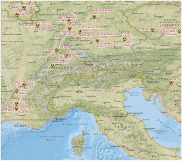
FIGURE 1 - Geographical distribution of NPP surrounding Northern Italy boundary line
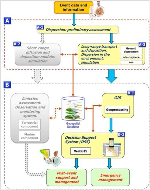
FIGURE 2 - DIFURAD operational workflow (the figure reports the so-called “light” version: the Modules not yet implemented are depicted as shadowed)
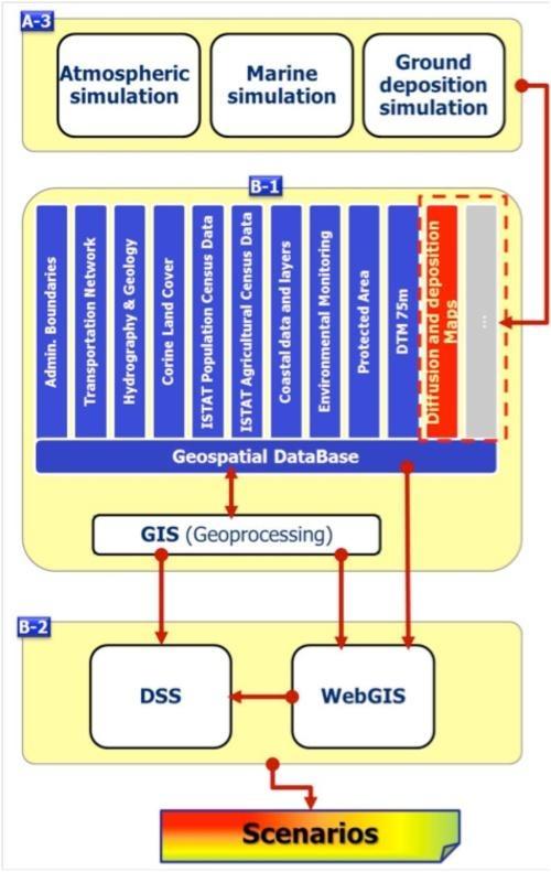
FIGURE 3 - DIFURAD schema: Simulation Modules, GIS and DSS
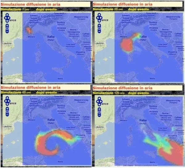
FIGURE 4 - Frames extracted from the simulation of the time evolution of radioactive pollution cloud
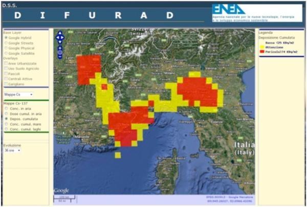
FIGURE 5 - Example of simulation of 137Cs ground deposition (36 hours after the event)
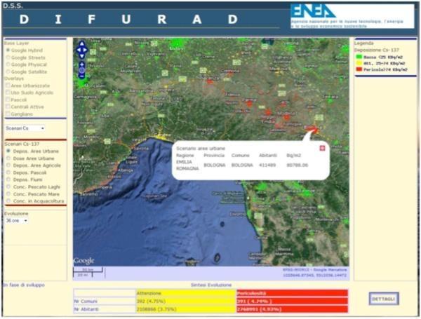
FIGURE 6 - Example of Scenario: 137Cs Cumulated ground deposition (Bq/m2) over Urban Areas. In the lower part of the WebGIS application it also possible to access detailed reports
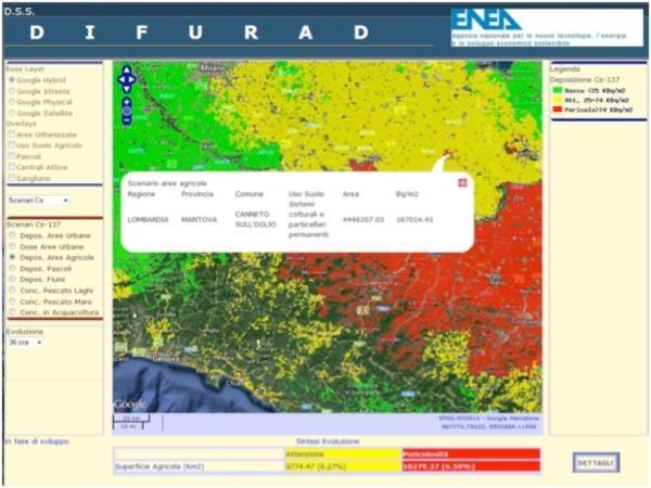
FIGURE 7 - Example of Scenario: 137Cs Cumulated ground deposition (Bq/m2) over rural land
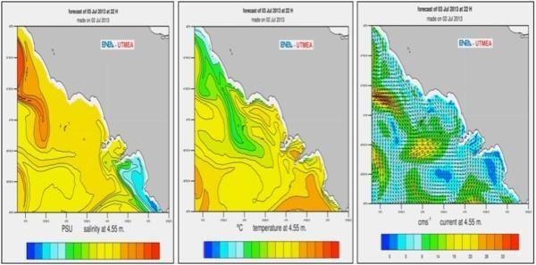
FIGURE 8 - Operational oceanographic model of Tyrrhenian Sea: simulation of salinity, temperature and currents
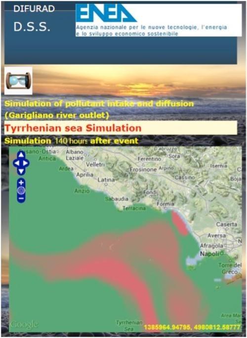
FIGURE 9 - Example of simulation of 137Cs release and diffusion in correspondence to the Garigliano river outlet (150 hours after the event)
R. Delfanti, M. Barsanti, I. Delbono - ENEA, Technical Unit for Marine Environment and Sustainable Development
M. Pollino, L. La Porta, A. di Sarra, V. Rosato, E. Napolitano, P.M. Ruti, V. Artale - ENEA, Technical Unit for Environment and Energy Modeling
M. D’Isidoro, G. Zanini - ENEA, Technical Unit for Models, Methods and Technologies for Environmental Assessments
S. Sandri, M. Guarracino, E. Fantuzzi - ENEA, Radiation Protection Institute
P. Agostini, R. Lorenzelli - ENEA, Technical Unit for Experimental Engineering
F. De Rosa, F. Padoani - ENEA, Technical Unit for Reactor Safety and Fuel Cycle Methods
E. Negrenti - ENEA, Technical Unit for Nuclear Fission Technologies and Facilities, and Nuclear Material Management
[1] Piano nazionale delle misure protettive contro le emergenze radiologiche, Dipartimento della Protezione Civile (2010)