

Historical heritage safeguard: remote sensing by drones for knowledge and emergency
The paper presents an innovative technology for the knowledge of the historical heritage with the use of Unmanned Aerial Vehicles (UAV) able to capture real-time data in inaccessible areas or in emergency situation. The technology, called LARS - Low Altitude Remote Sensing - is carried out by aircrafts, commonly called drones, with sensors mounted on carriers operating at low altitude.
The presented applications concern the monitoring of a landslide that affects the hill on which an historic centre is placed, the detail knowledge of a complex historical building for an appropriate restoration project, and finally the check of the damage state of the historical heritage in post-earthquake emergency
Tutela del patrimonio storico: telerilevamento tramite droni per conoscenza ed emergenza
L’articolo presenta una tecnologia innovativa per la conoscenza del patrimonio storico che utilizza aeromobili a pilotaggio remoto, noti come droni. La tecnologia, chiamata LARS – Low Altitude Remote Sensing – è capace di acquisire dati grazie a sensori montati su velivoli che operano a bassa quota. Le applicazioni presentate riguardano il monitoraggio di una frana che interessa la collina su cui sorge un centro storico, la conoscenza dettagliata di un complesso edificio storico finalizzata ad un progetto di restauro e, infine, il controllo dello stato di danno del patrimonio storico nell’emergenza post-terremoto
DOI: 10.12910/EAI2013-11
In July 2012, the authors, in agreement with the Municipality of Bondeno, a small town in the province of Ferrara, conducted a test on historical buildings damaged by the Emilia-Romagna earthquake. The test verified the effectiveness of Low Altitude Remote Sensing for the monitoring and management of earthquake emergency on historical heritage.
The studies continued during 2013 by applying the technology in areas with landslides hazard for detailed surveys and monitoring to safeguard the historical heritage, and on portions of historic centres in complex contests.
Remote sensing technology
Remote sensing includes techniques that allow to extract information about a reality placed at a known distance from the sensor; this technique allows the knowledge of the different characteristics of the investigated objects by the observation of electromagnetic radiation or acoustic energy by means of cameras, laser and radar, thermal devices, etc.; the platforms used for data acquisition are satellite, aerial or unmanned aerial vehicles.
The remote sensing methodology indicates not only the remote capture of qualitative and quantitative information regarding the territory and the environment, but also the set of methods and techniques for subsequent processing and interpretation [1].
If the acquisition is at high distance it is called Remote Sensing, if it happens at close range Proximal Sensing or Low Altitude Remote Sensing.
Low Altitude Remote Sensing
LARS (Low Altitude Remote Sensing) or UAV (Unmanned Aerial Vehicles) remote sensing is a set of techniques for collecting data through the use of various kinds of sensors operating at low altitude. The proximity sensing is used in all those cases where it is not possible or convenient to use the traditional platforms, satellite and airborne, to collect data from high altitudes. The technology is used in those contexts in which it can be useful to integrate data from different altitudes of observation too.
Applications range is from the field of geo-archeology, engineering, agriculture, applied geology to knowledge and monitoring of historical buildings, the control of portions of territory with high detail, in emergency as result of a natural or anthropic disaster [1].
The platform allows to acquire, at low altitude and with high resolution, structural and architectural details of buildings, and also to determine the conservation status, structural damage and collapse danger. The technology is particularly useful in cases where buildings are inaccessible due to serious damage.
The instrumentation used in the presented tests is constituted by an electric propulsion quadricopter and a helicopter with gasoline propulsion (Figure 1). On each aircraft a high resolution camera has been installed. The system of the helicopter has been modified by inserting a larger aluminium slide, a high-definition camera, heli commander, flight stabilization system, telemetry for real-time display of altitude, position and fuel levels [2].
The used quadricopter (Figure 2) was equipped with a tool for automatic control of positioning and stabilization, both of the aircraft and of the camera, so as to have the entire system perfectly orthogonal to the scene to be captured.
LARS for detail analyses on territory and buildings: study cases
The first study case concerns the image acquisitions of landslide structure over which lies the historic centre of San Martino in Pensilis, in Molise region. The area is situated in a hillside setting with sandy and clayey lithology. In the zone analysis, survey and monitoring are in progress in order to extract information about landslide arrangement.
The LARS has been used for detail knowledge of structural and decorative elements in the case of a complex building in the historic centre of Caporciano, damaged by the Abruzzo earthquake.
Another case study relates to a test carried out in the municipality of Bondeno, where acquisitions of historic buildings damaged by the earthquake in Emilia Romagna were performed. The test involved two churches and a fortified tower, UNESCO World Heritage.
Geomorphological study of a complex landslide in San Martino in Pensilis
The present work is part of a wider project that aims at the protection of historical-architectural and landscape heritage through integrated analysis with technologies for the safety of the historic centres in their totality and not as a set of buildings with different value. The historic centres, in fact, in addition to the individual economic value, have a historical, cultural and social value which must be protected as a whole [5].
In this perspective the landslide hazard assessment in the Municipality of San Martino in Pensilis, located at an altitude of 281 m above sea level in a hilly region of Molise, fits; in the area was planned relief and monitoring of landslide that affects one side of the hill on which the city centre stands (Figure 3) by way of integrated systems of photographic and topographic survey.
The historic centre of San Martino in Pensilis rises on a hill with sandy-clayey lithologies affected by landslides (paleo-landslides and quiescent landslides); the study area has an area with paleo-landslides covered with vegetation and tree farm, and a sector covered by natural vegetation with sandy-clay sediments mixed with landfill, located in the upper part of such structures. The preliminary geomorphological analysis was performed on aerial photogrammetry, geological mapping and through data of existing studies and in situ surveys.
The drone acquisitions are associated with a survey with terrestrial laser scanning technology [3]. Subsequently, the aircraft will be equipped with a thermal camera in order to identify areas at different moisture of the landslide and a possible non-effective drainage of rainwater. The collected data will provide information on the spatial distribution of the hydrogeological phenomena for the hazard assessment in the area.
Knowledge of an aggregate building for post-earthquake restoration in the historic centre of Caporciano (L’Aquila)
This application has been used in the context of integrated analysis [4] on an aggregate building (Figure 6, ph. 2) in the historic centre of Caporciano (Figure 6, ph. 1), carried out by ENEA researchers with C.A.Sa. architecture office in Pescara; the study predicted laser scanner survey, materials characterization testing, surveys with thermo-camera and detail acquisitions of the roofs through drones.
The aggregate building appeared very complex with various dimensions and different roofs; since there were not any points of view from other buildings that would allow an overview, a view from UAV (Figure 7) was required in order to verify also the conservation state.
The use of integrated methodology with innovative technology represented a valid method of providing information for the assessment of the vulnerability of architectonical heritage, considering the restoration and the consolidation of building in complex situations such as old town centres [4].
The technology has been used to survey and check the conservation state of the building roofs. Images at different angles of the building were acquired in order to get different views of the roofs and check their condition (Figure 8).
Emergency: historical heritage damaged by the Emilia Romagna earthquake in the Municipality of Bondeno
The Municipality of Bondeno, situated in the province of Ferrara, was hit by the earthquake in Emilia-Romagna on May 20th and 29th and a large part of its architectural heritage has been severely damaged [5].
The territory of Bondeno has been severely affected by the earthquake, from the centre to the periphery: houses, industrial buildings and historic buildings. Many buildings have been declared unsafe especially the masonry structures in the heart of the city. All the churches in the territory of the Municipality were declared unsafe and closed [5].
Tests were performed in Rocca Possente, a military fortress, on the church and the bell tower of San Giovanni, outside the historic centre and the church of the Natività di Maria with its bell tower, called Matildica church, in the heart of the historic centre.
Rocca Possente, UNESCO World Heritage
The fortress, UNESCO World Heritage since 1999, is situated in Stellata place, surrounded by a beautiful landscape on the right bank of the Po river. Four different acquisitions were performed, one for each side [6]. Three acquisitions were carried out with helicopter, the fourth on the main façade through smaller quadricopter; in fact, the presence of the staircase leading to the first floor, a small building facing the fortress and the presence of various obstacles did not leave enough operating space for the helicopter, of larger dimensions.
Church and Bell Tower of San Giovanni
The church of San Giovanni is located in the urban centre, in the entrance of the city coming from Ferrara. The main façade of the church suffered a severe crack from the architrave of the main access portal to the tympanum, visible from the ground [5]. The bell tower showed some cracks but inspecting the top part of the cornices at different levels of the steeple was not possible. So an acquisition from close range and in altitude was needed.
The high-resolution helicopter acquisitions (photos 3 & 4 in Figure 12) have provided technicians and designers with useful information for the safety intervention on the bell tower.
Church of Natività di Maria
The Church of Natività di Maria, called Matildica Church, cathedral in the municipality of Bondeno, is situated in the historic centre (Figure 13).
The church had serious cracks in the apse and on the vaults with some partial collapse. In the bell tower the detachment of the internal stairs from the perimeter walls occurred and the vaults are damaged [5]. Firefighters intervened on the top of the church façade to remove a detached spear (ph. 1&2 in Figure 14), to prevent its overturning.
The acquisitions included the main façade (ph. 2 in Figure 13), the two side elevations and the bell tower in the façade facing the square (ph. 3 in Figure 13). Detail acquisitions (Figure 14) showed damage caused by the earthquake (ph. 2 in Figure 14) but also the conservation state of the architectural and decorative elements (ph. 3 in Figure 14).
Considerations
The UAV remote sensing is a low-cost technology in terms of equipment and maintenance and is used when it is not possible or convenient to use the traditional platforms, satellite and airborne, to collect data in inaccessible area for height or collapse damage or after a natural disaster.
It’s possible to equip the radio-controlled aircrafts with different sensors for multiple acquisitions such as thermal and multispectral cameras, or environmental sensors that allow data collection in real time or the drafting of damage maps in hazard or emergency situations.
The Low Altitude Remote Sensing is therefore a technique that can integrate the usual methodology of survey. The integrated analysis becomes a monitoring tool to safeguard the territory and the historical heritage by providing their knowledge and conservation status [4].
Acknowledgements
The authors thank the municipal authorities and technical office of San Martino in Pensilis and Bondeno Municipalities for their availability and the resources put at disposal.
Nice thanks to Paola Giaquinto and Roberto Ciardi, ENEA Rome, for the photos during the acquisitions in Rocca Possente and for the video realized for the ENEA WebTV (http://webtv.sede.enea.it/index.php?page=listafilmcat2&idfilm=686&idcat=22). Special thanks are due to Cavinato Company for their technical assistance during the flight acquisitions.
References
- T.M. Lillesang, R.W. Kiefer, J.W. Chipman 2004. Remote Sensing and Image Interpretation, fifth edition, John Wiley & Sons Ed. pp763.
- E. Candigliota, F. Immordino 2013. Low Altitude Remote Sensing by UAV for monitoring and emergency management on historical heritage. ANIDIS Congress, Padova 30 June-4 July.
- E. Candigliota, F. Immordino, D. Costantino, G. Abate, 2013. Centri storici e conservazione: rilievo e monitoraggio di un fenomeno franoso a San Martino in Pensilis (CB). Abstract book, 7° workshop tematico “Il telerilevamento per il monitoraggio e la gestione del territorio”, San Martino in Pensilis, 13-14 June, 13-14 pp.
- F. Armillotta., D. Abate, E. Candigliota, F. Immordino, S. Pierattini, C. Santacroce. 2013. Integrated technologies for structural assessment of historic buildings: case-study in Caporciano (AQ), Convegno ANIDIS, Padova 30 June - 4 July.
- E. Candigliota, B. Carpani, F. Immordino,A. Poggianti 2012. Damage to religious buildings due to the Pianura Padana Emiliana earthquake, EAI Energia Ambiente ed Innovazione, 4-5 part II, 58-68.
- P. Giaquinto, R. Ciardi, 2012. Droni in azione per la verifica degli immobili danneggiati dal sisma. WebTV ENEA Video, July. http://webtv.sede.enea.it/index.php?page=listafilmcat2&idfilm=686&idcat=22
Elena Candigliota, Francesco Immordino - ENEA, Technical Unit for Seismic Engineering
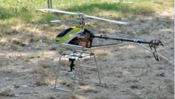
FIGURE 1 - Radio-controlled Helicopter with gasoline propulsion
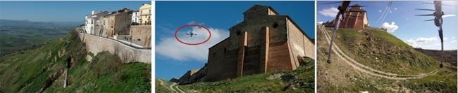
FIGURE 5 - Historic centre view (ph. 1), drone in action on the landslide (ph. 2), image captured by drone camera
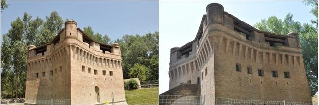
FIGURE 9 - Views of Rocca Possente, Stellata place, Municipality of Bondeno
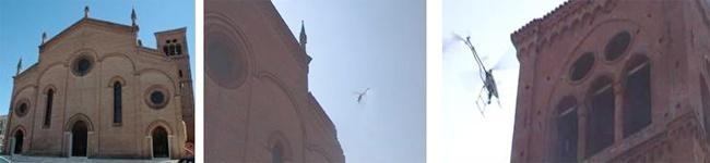
FIGURE 13 - Matildica Church façade (ph. 1), helicopter during the image acquisition (ph. 2&3)
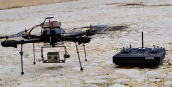
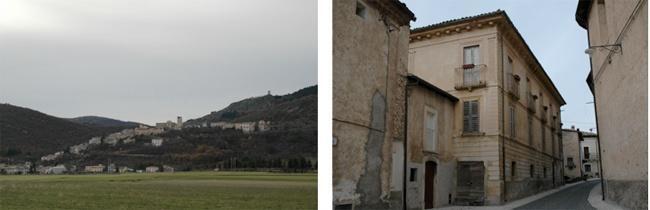
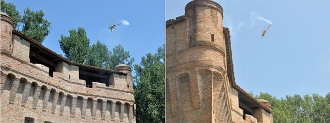
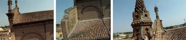
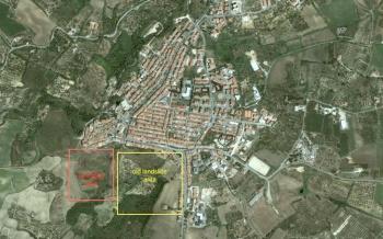
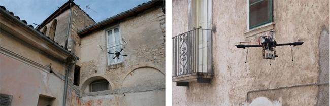
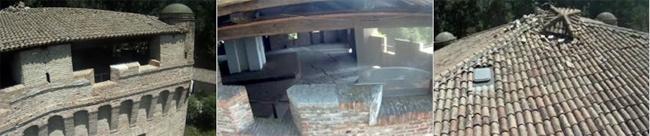
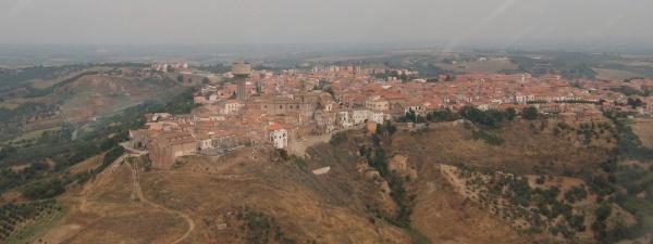
FIGURE 4 - San Martino in Pensilis: panoramic view of urban centre - Source: Municipality of San Martino in Pensilis
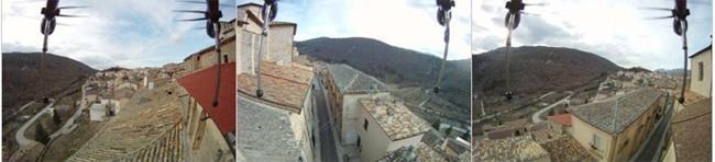
FIGURE 8 - View of roofs by quadricopter camera
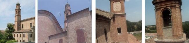
FIGURE 12 - Church of San Giovanni in Municipality of Bondeno: view of the bell tower (ph. 1), helicopter in action for steeple image acquisitions (ph. 2), helicopter views (ph. 3&4)